maacgis
Climate Response and Virginia Archaeology: Maps from Different Points of View
This project is maintained by aejolene
Climate Response and Virginia Archaeology: Maps from Different Points of View
Jolene Smith, Virginia Department of Historic Resources
A Paper for the 48th Annual Middle Atlantic Archaeology Conference in Virginia Beach, VA. March 17, 2018.
In Geospatial Studies in Middle Atlantic Archaeology Session Organizer: Yvonne French (Northern Virginia Chapter, Archeological Society of Virginia)
Introduction: Expectations for climate change impacts
According to the Fourth National Climate Assessment published by the U.S. Global Change Research Program in November 2017, mid-Atlantic sea levels are projected to rise between 1 and 2 meters by the year 2100 (USGCRP 2017). Instability of sea ice introduces even more uncertainty, and differences in mass of land and sea ice produce varying rates of projected rise.
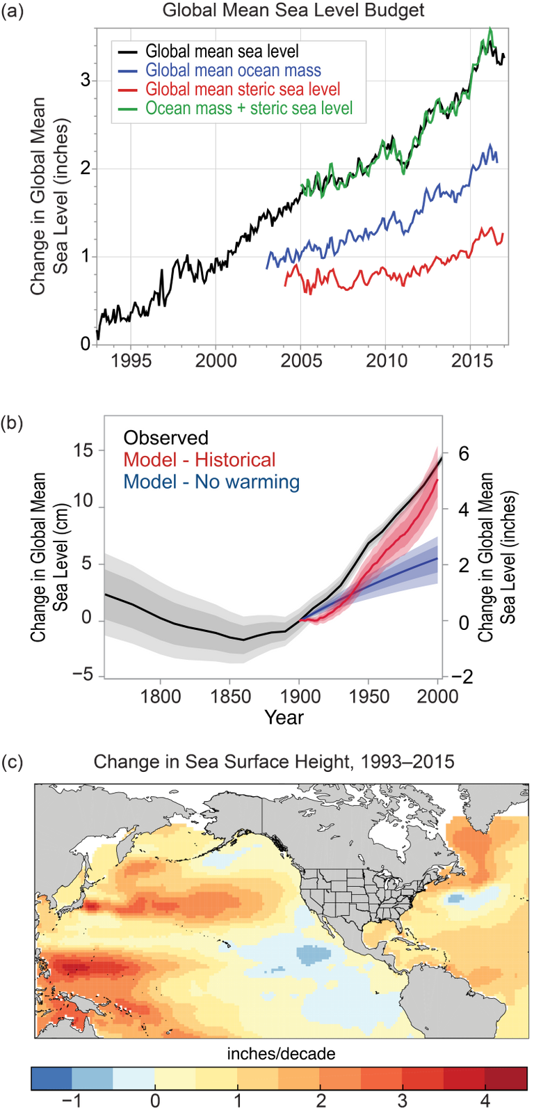 “Changes in Sea Level in Sea Surface Height” from USGCRP 2017
In addition to rising seas, changing global temperatures alter sea currents and weather patterns, causing an increase in the occurrence of severe storms and changes to the rates of shoreline erosion. The shoreline of the Chesapeake Bay in Virginia alone stretches over 7,000 miles (Berman 2010). It is no surprise to any archaeologist that a large proportion of human habitation sites stretching back millennia are in close proximity to the coast and shorelines and are imminently threatened.
How we plan
In Virginia, we maintain records on around 44,000 archaeological sites, with more being added every day. In response to new priorities from the administration of Governor Terry McAullife in 2014, the Department of Historic Resources established a “Climate Change Impact Area” in order to monitor resources and target survey. To derive this area, DHR staff combined Category 4 storm surge area data (Virginia Department of Emergency Management 2013) and the projected area to be inundated with a 5’ sea level rise (NOAA 2013).
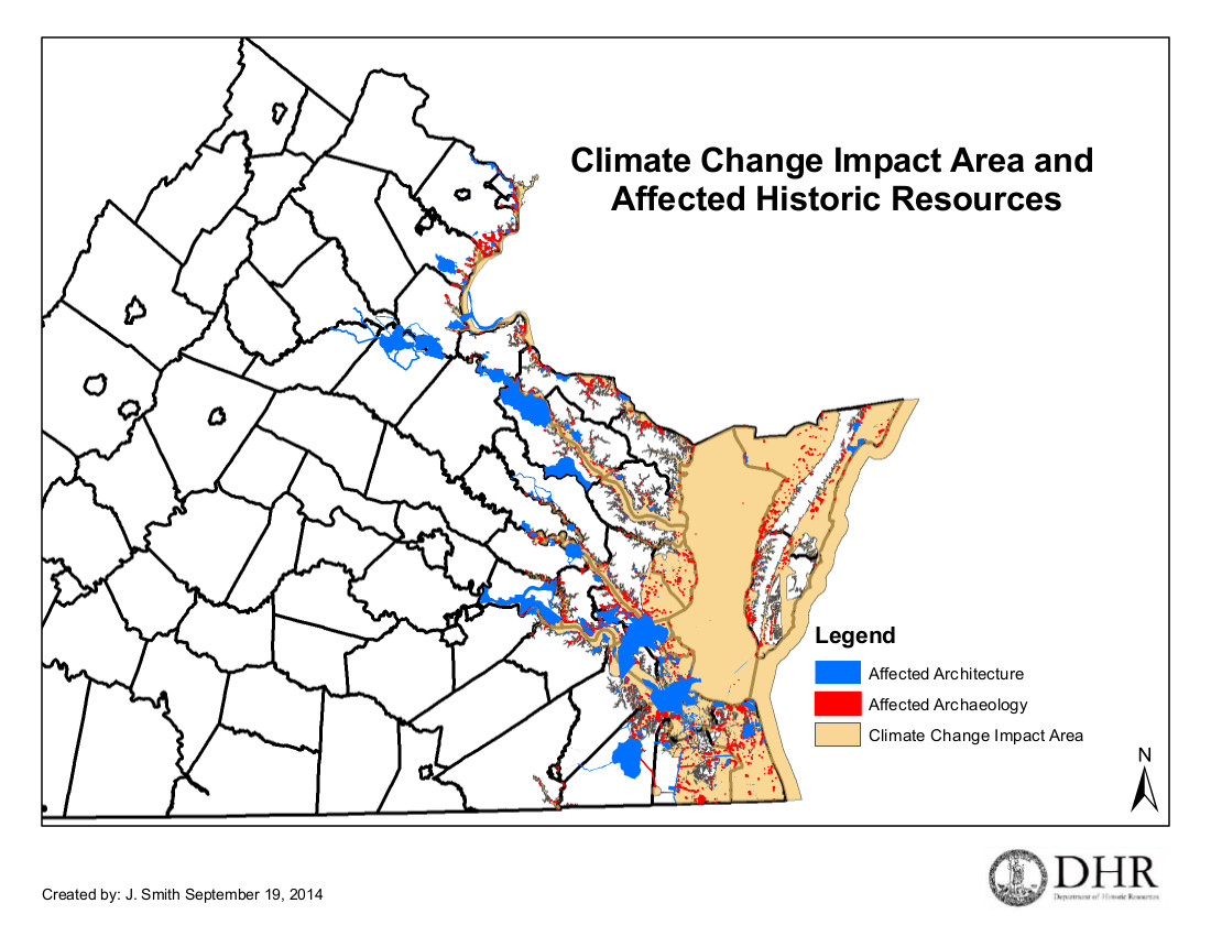
Virginia DHR’s Climate Change Impact Area (2014).
The goal of the area was not to predict which sites and above-ground historic properties would be flooded, but to instead target increased attention and documentation. The zone contains more than ten percent of all recorded archaeological sites and archaeological resources in the Commonwealth. Only a small percent of this area has been systematically surveyed for archaeological sites prior to 2013. The richness of our coastal heritage (not to mention the interconnected ecosystems) cannot be overstated.
In 2017, researchers from the Digital Index of North American Archaeology (DINAA) published a powerful article that demonstrated the magnitude of the potential impact to archaeological resources on the East Coast. (Anderson et al. 2017). Critically, this study not only examined areas very near the coast and at risk from direct, water-related impacts, but it also considered risks that might be caused by displacement of major population centers from the coasts inland. In Virginia, entire regions like Hampton Roads will likely feel pressures away from shorelines and rising water tables.
The DINAA study considered archaeological sites from nine coastal states and found that over 19,000 sites will be inundated with a 1 meter sea level rise (a likely scenario within a century). In Virginia alone, a change in sea level at that magnitude will flood around 7,000 recorded sites, over 1,000 of which are at least potentially eligible for listing on the National Register of Historic Places (Anderson et al. 2017). The implications of coastal demographic displacement are even more striking. In Virginia, over 70% (n = 32181) of all recorded archaeological sites are within DINAA’s considered 200 km distance from the coast.
“Site incidence as it relates to potential loss from sea-level rise, grouped by elevation in meters above present mean sea level.” from Anderson et al. 2017
Funding made available by the National Park Service after Hurricane Sandy devastated the mid- and north-Atlantic coast in 2012 enabled the Department of Historic Resources to engage in systematic assessment of individual sites and properties. The agency published a request for proposals in order to design a study that would assess change to recorded archaeological sites in several eligible counties. The Longwood Institute of Archaeology produced a methodology that combines a vulnerability assessment using statistical methods to make high-resolution predictions about coastal change rates with a geospatial predictive model in order to prioritize sites requiring physical assessment among thousands in coastal and shoreline areas (Rose et al. 2017).
 An example of site vulnerability map from Rose et al. 2017. Site locator and site numbers redacted
These three initiatives address risk to sites at three very different scales — continental, statewide, and site-level. Taken together, these and similar approaches make up a powerful planning toolbox as we come to terms with the realities of climate change and its impacts.
How we respond and recover
Within the life cycle of a disaster, impacts to and protections for cultural resources can be found at any level (FEMA 2011). Disaster response is, by its very nature, a speedier and more time-sensitive affair. Human health and safety along with economic stability rank at the top of priority lists. Still, recovery officers have an opportunity to protect and document archaeological sites and other cultural resources. During the recovery phase, communities begin to put the pieces back together.
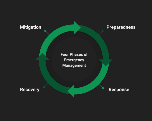
The four phases of emergency management. Consideration of cultural resources can happen at all phases, but occurs mostly during recovery.
The SHPO (state historic preservation office) maintains an inventory of cultural resources. Our task is to figure out the best ways to convey these data and their meaning appropriately to many different audiences who may not have archaeological or architectural history expertise. Potential audiences include disaster response personnel from federal agencies, state agencies, and local governments, planners at the local level, and other state and federal agency staff who may find themselves involved in compliance with Section 106 the National Historic Preservation Act due to recovery-related federal undertakings. Other audiences include property owners, descendent communities, and members of the general public with an interest in archaeology and preservation.
Risks of sharing too much data
In order to address disasters (and facilitate research, provide public outreach, ethically and effectively manage historic resources, et cetera), sharing data is central. We need to be able to communicate clearly and quickly to non-archaeologists what we have and why it’s important. But it is easy to overshoot, and the consequences can be severe and permanent (Smith 2016).
Data managers (myself absolutely included) take archaeological site sensitivity very seriously. Section 304 of the National Historic Preservation Act of 1966 (16 U.S.C. 4702-3) indicates that officials
“shall withhold from disclosure to the public information about the location, character, or ownership of a historic property if the Secretary and the agency determine that disclosure may-
(1) cause a significant invasion of privacy; (2) risk harm to the historic property; or (3) impede the use of a traditional religious site by practitioners”
For archaeological sites, this generally means restricting access to specific details about the location and nature of sites (this is interpreted in a myriad of different ways, but that’s another paper).
In an emergency, people who need to understand impacts to archaeological sites may not be professional archaeologists or trained in cultural resource management. They may not understand the sensitive nature of archaeological sites. Distributing static geospatial data at full resolution creates particular vulnerabilities, as a .zip archive of GIS shapefiles is easy to share and can find its way onto public-facing websites very easily. Releasing detailed locations of certain types of archaeological sites (namely those including Virginia Indian human remains and grave goods, as well as shipwrecks, Civil War and Colonial-era sites) places them at high risk for looting and vandalism.
Even if archaeological data stays safely out of the hands of bad actors, we risk overwhelming people outside of the cultural resource management world with too much information presented in potentially confusing ways. For example, take a concurrence from the Department of Historic Resources that a resource is potentially eligible for listing on the National Register of Historic Places, even though in reality all historic properties are technically (usually) potentially eligible until evaluated to be ineligible. It’s confusing. Archaeological boundaries can also be misleading. Does a polygon represent the entirety of a site, or is it limited to the portion surveyed for a particular project? It takes a certain degree of training to correctly interpret what can be a torrent of data. Compound with a tense emergency situation and overextended staff and the risks for mistakes continue to grow.
Risks of sharing too little
Because sharing just the right amount of archaeological data is not simple, many data repositories take the conservative approach of withholding everything archaeological from public-facing applications, for fear of making an irreversible mistake. While it’s true that we can’t un-ring the bell of sensitive data release, there are other consequences to keeping things too close to the belt. In the wake of a disaster, a property owner, a concerned citizen, or even someone working outside of a cultural resources division for a government agency might not even realize there are resources at risk in a given area. With no easy avenue to help, we might lose even more of our irreplaceable cultural heritage.
We can explore ways to achieve a balance between the restrictive and vulnerable ends of the spectrum by opening up non-sensitive data and displaying it ways that meet specific needs and answer particular questions.
Examples:
Agency response map
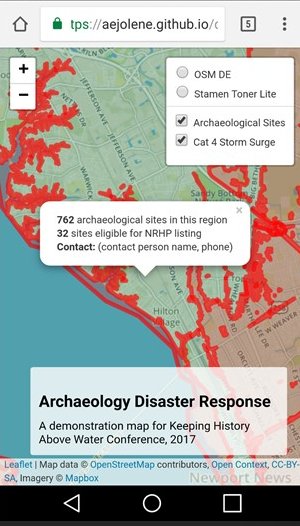
From Smith et al. 2017, Using the Digital Index of North American Archaeology for Rapid Disaster Response and Reporting
Pictured above is a demonstration mobile app created for the Keeping History Above Water conference in Annapolis, MD (2017). The accompanying paper, “Using the Digital Index of North American Archaeology for Rapid Disaster Response and Reporting,” is available online, along with the code for the map (Smith et al. 2017). The authors demonstrate how archaeology data available at a safe, public scale can be used to create a tool to quickly connect agency responders with SHPO staff, using a presence/absence map that works on mobile devices.
Explore the Interactive Disaster Response Demo Map
Crowdsourcing conditions- citizen science
In Virginia, we are strapped for funds and personnel within the SHPO to conduct monitoring of vulnerable sites. Each year, we get reports of eroding cultural materials, sometimes including material remains. The fact is we can’t do this alone with the limited resources of a small state agency. How do we involve others in this monumental and never-ending task?
Drawing on methodology successfully implemented by the SCAPE/SCHARP project in Scotland (Dawson 2017), Virginia and other coastal states could quickly deploy volunteer data collectors to aid in site monitoring and discovery. But the correlation between archaeology in Scotland and archaeology in the United States is not 1:1. Fewer legal protections and, arguably, less of a communal stewardship ethic introduce perceived added risk for intentional looting and destruction. Fortunately, in this state we’ve got the remarkable Archeological Society of Virginia, a large avocational archaeology organization including members with decades of training and experience, as well as a high degree of collaboration with the professional archaeological community. Here is where we start.
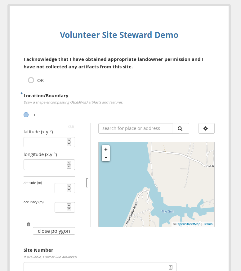
A demo for volunteer “Site Steward” data collection, created using KoboToolbox.
Try the data collection app (on mobile or desktop)
Sharing information to build coalitions- WHO CARES?
Beyond the dedicated ASV members, we must find new ways to bring Virginia’s archaeological heritage into the broader public consciousness. In order for a resource to warrant community protection and preservation, it has to be valued. How can we expect those outside of our own profession to understand the intrinsic value of archaeology when most people have no idea they are surrounded by thousands of years of material culture? This question applies both to citizens and decision makers. If we want our leaders and communities to come to bat for these sites, we’ve got some work to do.
In the coming years, it will be more critical then ever to prioritize outreach, take the time and effort to create maps safe for distribution, and make our archaeological data engaging and accessible (Smith 2016b).
In Conclusion
Building in flexibility to view our GIS data in many ways can have implications far beyond climate change. While this paper comes from the perspective of a SHPO archaeologist, I argue that the principles and approaches are also relevant to people outside of DHR. We can all build in consideration for public dissemination at the outset with simple strategies like formatting reports to easily remove sensitive data. We can make data interoperable by planning for its reuse and choosing stable, non-proprietary file formats. These strategies might seem tangential to addressing response to climate change impacts, but they’re core to getting the right level of information out into the world. Our geospatial data is rich and valuable. By finding new ways to view it, we can expand our reach beyond a small subset of trained professionals and exponentially expand our reach and influence, protecting sites and documenting our irreplaceable heritage.
References
Anderson, David G., Thaddeus G. Bissett, Stephen J. Yerka, Joshua J. Wells, Eric C. Kansa, Sarah W. Kansa, Kelsey Noack Myers, R. Carl DeMuth, and Devin A. White. 2017. “Sea-Level Rise and Archaeological Site Destruction: An Example from the Southeastern United States Using DINAA (Digital Index of North American Archaeology).” PLOS ONE 12 (11): e0188142. https://doi.org/10.1371/journal.pone.0188142.
Berman, Marcia. 2010. “How Long Is Virginia’s Shoreline?” The Length of the Commonwealth’s Shoreline. April 2, 2010. http://www.vims.edu/bayinfo/faqs/shoreline_miles.php.
Dawson, Tom. 2017. “The Steps to Prioritizing and Undertaking Action at Sites Threatened by Climate Change: Incorporating a Citizen Science Approach into Heritage Management in Scotland.” _With A World of Heritage So Rich: Lessons from Across the Globe for U.S. Historic Preservation in Its Second 50 Years. US/ICOMOS. https://research-repository.st-andrews.ac.uk/bitstream/handle/10023/10074/DawsonWorld_Of_Heritage_So_Rich_.pdf
FEMA. 2011. “National Disaster Recovery Framework.” https://www.fema.gov/pdf/recoveryframework/ndrf.pdf.
Rose, Craig, Mary Farrell, Brian Bates, Walter Witschey, Erin West. 2017 Archaeological Shoreline Survey, Portions of Lancaster, Mathews, Middlesex, and Northumberland Counties, Virginia. Longwood Institute of Archaeology.
Smith, Jolene. 2016. “Approaches to Openness.” Society for Historical Archaeology, Baltimore, MD. https://jolenesmith.net/approaches-to-openness/html.
Smith, Jolene. 2016. “Archaeology for Everyone: A Public Digital Repository. White Paper for the Institute on Digital Archaeology Method and Practice.” http://vaarchaeology.matrix.msu.edu/about/.
Smith, Jolene, David G. Anderson, Eric Kansa, Joshua Wells, and Stephen Yerka. 2017. “Using the Digital Index of North American Archaeology for Rapid Disaster Response and Reporting.” Keeping History Above Water, Annapolis, MD. https://github.com/aejolene/disastermap.
USGCRP. 2017. “Climate Science Special Report Chapter 12: Sea Level Rise.” 2017. https://science2017.globalchange.gov/chapter/12/.